BBC Four series on "The Beauty of Maps"
Library of Congress exhibit
Curiosities: Maps That Will Change the Way You See the World
a very different approach in mapping social data based on population rather than land area: http://www.worldmapper.org/
Asia in the middle: http://www.wsfly.com/Resources/Uploads/Images/world201401.jpg
America in the middle: https://stephenliddell.files.wordpress.com/2012/09/world-map.gif
Europe in the middle: http://www.h3dwallpapers.com/wp-content/uploads/2014/09/Map_of_the_world-12.gif
UPSIDE DOWN
a tumblr all about amazing maps for anyone ho REALLY like maps :) Beware, hours of your life may disapear: http://mapsdesign.tumblr.com/
http://www.viewsoftheworld.net
Criticisms of the Mercator Projection from "The West Wing"
10 Beautiful Medieval Maps
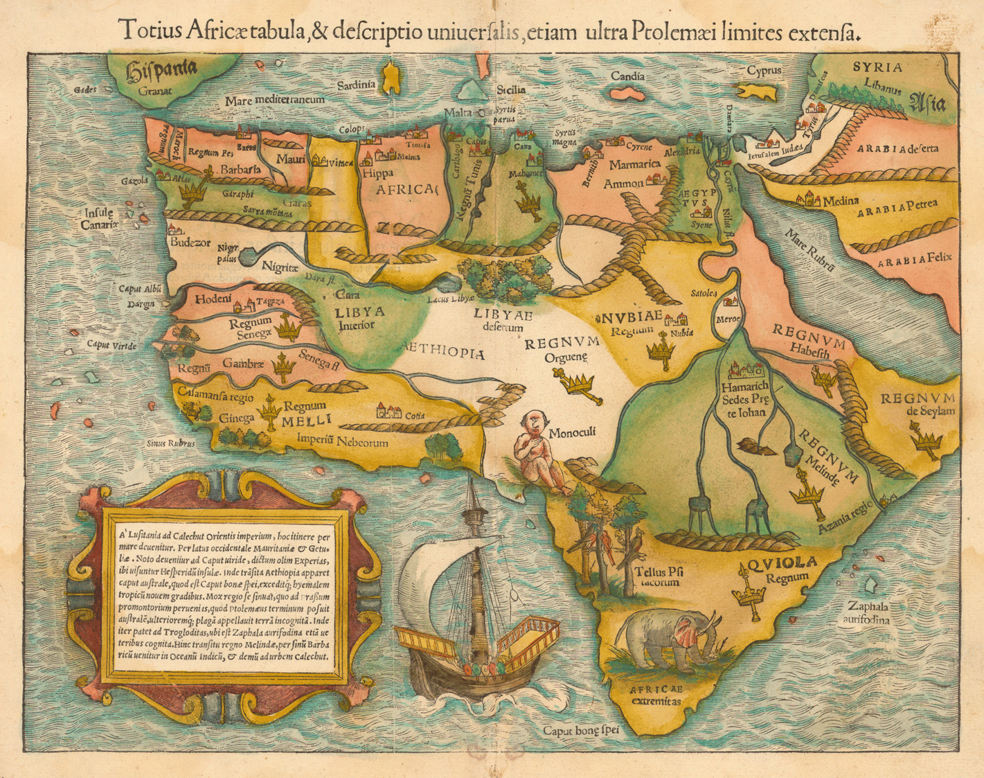
Here the first map of the whole continent of Africa, drawn in 1552 by Sebastian Münster. He was a professor of Hebrew at Heidelberg and later in Basel where he died of the plague in 1552. Münster was the most influential cartographer in the mid 16th century. This map indicates many interesting things, like the one-eyed giant in Nigeria and Cameroon or the elephant who is placed in southern Africa.
http://libweb5.princeton.edu/visual_materials/maps/websites/africa/maps-continent/1554munster.jpg
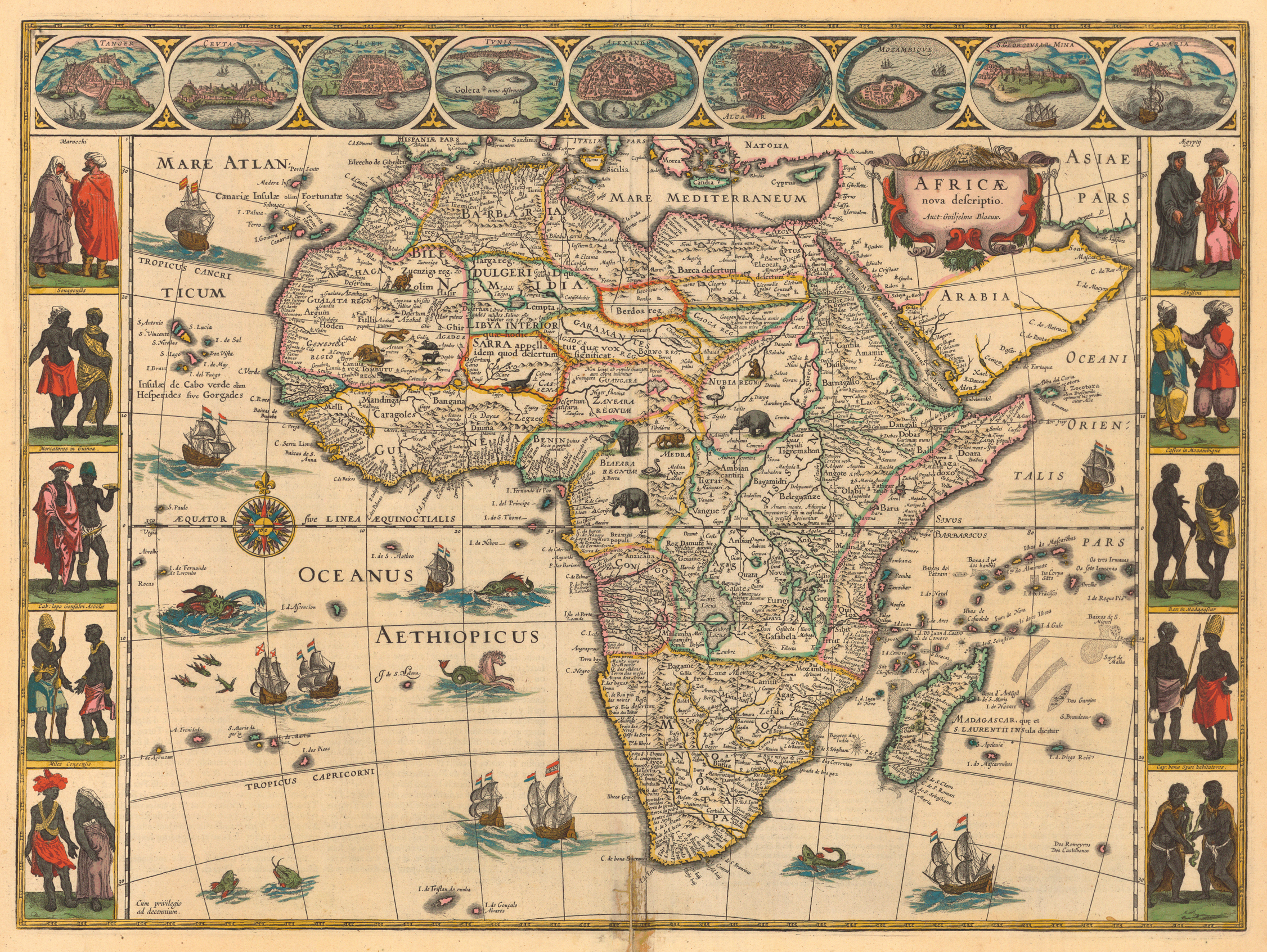
And just a few years later, 1584, Abraham Ortelius (Belgium) showed another map which is very different as the other one: Africa assumes a more recognizable shape, Madagascar appears. The map indicates no animal or plant except in the water the swordfish and the whale. http://libweb5.princeton.edu/visual_materials/maps/websites/africa/maps-continent/1644%20blaeu.jpg
Library of Congress exhibit
Curiosities: Maps That Will Change the Way You See the World
a very different approach in mapping social data based on population rather than land area: http://www.worldmapper.org/
Asia in the middle: http://www.wsfly.com/Resources/Uploads/Images/world201401.jpg
America in the middle: https://stephenliddell.files.wordpress.com/2012/09/world-map.gif
Europe in the middle: http://www.h3dwallpapers.com/wp-content/uploads/2014/09/Map_of_the_world-12.gif
UPSIDE DOWN
a tumblr all about amazing maps for anyone ho REALLY like maps :) Beware, hours of your life may disapear: http://mapsdesign.tumblr.com/
http://www.viewsoftheworld.net
Criticisms of the Mercator Projection from "The West Wing"
10 Beautiful Medieval Maps
Here the first map of the whole continent of Africa, drawn in 1552 by Sebastian Münster. He was a professor of Hebrew at Heidelberg and later in Basel where he died of the plague in 1552. Münster was the most influential cartographer in the mid 16th century. This map indicates many interesting things, like the one-eyed giant in Nigeria and Cameroon or the elephant who is placed in southern Africa.
http://libweb5.princeton.edu/visual_materials/maps/websites/africa/maps-continent/1554munster.jpg
And just a few years later, 1584, Abraham Ortelius (Belgium) showed another map which is very different as the other one: Africa assumes a more recognizable shape, Madagascar appears. The map indicates no animal or plant except in the water the swordfish and the whale. http://libweb5.princeton.edu/visual_materials/maps/websites/africa/maps-continent/1644%20blaeu.jpg
No comments:
Post a Comment